Showing posts with label maps. Show all posts

26 October 2012

History of Maps

After my post on Wednesday I thought I'd do a rundown of how maps evolved. Why not? I'm going to start with a section from that post and go from there.

A History of Maps!

The earliest map we have is the Babylonian Imago Mundi from 600 BCE. The clay tablet shows Babylon at the heart of a seven-pointed star of islands. The accompanying text describes three of the islands:

1-"place of the rising sun"
2-"the sun is hidden and nothing can be seen"
3-"beyond the flight of birds"

Babylonian Imago Mundi
The idea of the nation drawing the map being at the center of the world would continue throughout the ages. Human nature creates a false sense of center. We all think we are the center of the world. It has led to flat world theories, the earth being the center of the universe, and numerous wars.

Similarly Anaximander created an Aegean-centered world map  c. 610 BCE. This map would form the basis of most cartography for the next 700 years. Each generation slightly improving upon the original.

The incremental changes built up until we get to Ptolemy's map c. 150. This new map revolutionized the concepts of cartography. Ptolemy introduced longitude and latitude as well as aligning terrestrial and celestial observations. His ideas and descriptions would influence map makers for over 1000 years.

15th century reconstruction of Ptolemy's World Map

Ptolemy did not draw a map that exists to modern times. In the 1300s his manuscript for Geographia was rediscovered and promptly people started drawing maps based on his descriptions. The map is flawed but set people in the right direction. Within 100 years we would have maps that begin to look like the world as it truly is.
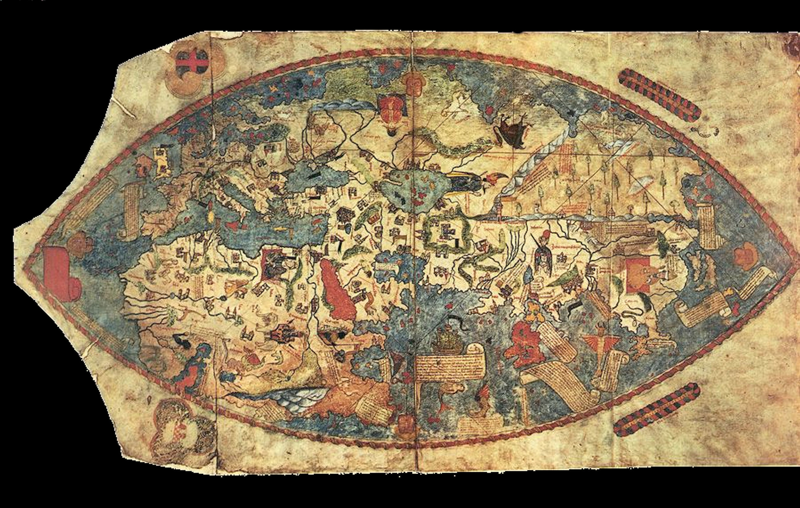
Genoese map of 1457

While the Genoese map is somewhat confusing to look at, Europe, northern Africa, and Asia are all clear and mostly the right shapes.

What I would consider an early true 'modern' looking map of the whole world is the Theatrum Orbis Terrarum (1570) by Abraham Ortelius. 60 years later the Nova totius Terrarum Orbis (1630) by Hendrik Hondius. This map is basically the world as it is.

And it only took 2200 years!

Nova totius Terrarum Orbis (1630)

24 October 2012

Map Supplemental Appendix 1

I try not to get too political on this blog. I leave that to my Twitters and Facebooks. But Mitt Romney has not seen a map of Iran. Clearly.

via National Review

This is why maps are important. In one glance Romney could have come up with a better statement. Iran controls many seaports, thus is important to U.S. interests in the area. Syria has nothing to do with that. Not in this way.

MAPS!

Map Supplemental

Saul Steinberg

I forgot one of my favorite weird maps. This cover to the New Yorker from 1976 is the view of the world from 9th Avenue in New York.

It is amazing for it's simple graphic depiction of the bubble that is New York City. Also of note...no Europe. America with its back to its neighbor across the Atlantic...hmmm

In light of the lack of Euro discussion this election cycle I feel like it is oddly appropriate.

Dust Jacket : The Second World War

The Second World War
Jacket Design: Steve Marking

Steve Marking is the current art director at Orion Books. He previously worked for Penguin UK as a senior designer. His credentials are on point.

This cover is pretty spectacular. If you've been reading Dust Jacket for any length of time you know that I clearly love me some text-based design. In fact, this cover is so very similar to the cover of Orphan Master's Son that I almost didn't pick it.


But it gives me the chance to discuss maps, which are a huge love of mine.

So maps.

The earliest map we have is the Babylonian Imago Mundi from 600 BCE. The clay tablet shows Babylon at the heart of a seven-pointed star of islands. The accompanying text describes three of the islands:

1-"place of the rising sun"
2-"the sun is hidden and nothing can be seen"
3-"beyond the flight of birds"

Babylonian Imago Mundi
This map is beautiful for its simplicity. An attempt to place the self in the broader world. To contextualize. This is the first reason I love maps. They take the wilds and make them feel like home. If you can know something you can be master of it.

Maps are colonialism.

This may not be beautiful when you start to project from the statement, it is a beautiful sentiment. That you can know something by laying it down.

At their base level maps are simply lines. The flowing lines of nature and the grid of man. At times they can be completely hypnotic and surreal:

Harold Fisk - Historical trace of the Mississippi  (1944)
I mean. Look at that. You want to drown in it. Cover your walls, become obsessive. I understand people who never leave their apartments and fill notebooks. They are drawing that.

And it is real!

On the other end of the spectrum are the maps where things are just crazy.

To the right is a 15th century engraving of Ptolemy's description of the world. It was printed only a few years before Columbus' first voyage. Nothing is real. It is manic, full of strange locations, and the world is a smooshed mess. But it is magical and it was the standard for 1000 years. Imagine believing that the world looked like that. What it would feel like.

The drawings around them are amazing and fun to look at. Modern maps have given way to too much realism. I want a little of that magic back. Which ties back to our cover. By simply adding the text that map becomes more than a detail of the Atlantic Ocean. Something ominous begins to hover over it. Something dark.
Carta Marina (1539)
Click the caption to see that in full size. It is amazing. You will spend hours with it. Modern satellite imaging has shown that many of the locations of the sea creatures and monsters are actually locations of weather patterns and known storm areas. So the threat was real. Imagine weather patterns represented by monsters.

Today's forecast is for dragons over the plains and serpents along the eastern seaboard.


Dust Jacket is a sometime article about the design and art of book covers. The idea is to shine a spotlight on the work of the designer separate from the author. Literally judging a book by its cover.